Ground penetrating radar is a cost-effective & nondestructive geophysical method, which is used for generating a continuous cross-sectional profile of the subsurface features, without drilling, probing, or digging. Ground penetrating radar (GPR) is the technique, which is used for determining the location and depth of buried objects in the earth or concrete. It allows us to locate rebar, pipes, cables, voids and other sub-surface features. GPR can also be used for investigating the presence and continuity of natural subsurface conditions and features.
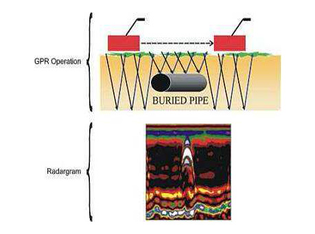
In Ground penetrating radar Survey, pulses of ultra high frequency radio waves (microwave electromagnetic energy) are transmitted down into the ground using a transducer or antenna. The ground penetrating radar antennas (transducer) are pulled along the grid lines on the ground by an operator or by a vehicle. The transmitted signal entering in the ground comes in contact with objects or subsurface strata having different electrical conductivities and dielectric constants and is reflected back. Some part of the ground penetrating radar waves get reflected off of the object or interface; while the balance part of the waves pass through the object and travel to the next interface.
The reflected signals return to the antenna, pass through the antenna, and are received & stored by the basic digital control unit. The control unit registers the reflections against two-way travel time in nanoseconds and then amplifies the signals. The output signal voltage peaks are plotted on the ground penetrating radar profile as different color bands by the digital control unit.
The depth of penetration is determined by the frequency of antennas used and the type of sub-surface material. Ground penetrating radar waves can penetrate deeper in low conductivity materials such as dry sand or granite in comparison to clays, shale, and other high conductivity materials because of attenuation of GPR signals in highly conductive material. Lower is the frequency deeper the penetration and vice versa.
Applications: