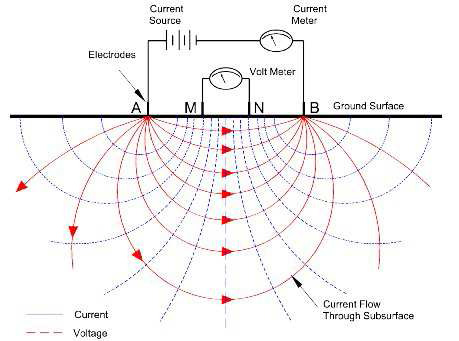
Electrical Resistivity is the geophysical method used to measure the apparent resistivity of the subsurface material, which eventually measures and detect the effects of variation of ground water, soil type, bedrock fractures and contaminants. Variations in electrical resistivity may indicate changes in ground water potential, composition, layer thickness or contaminant levels.
Read More
Seismic Methods are the geophysical methods, which can provide great information about stratigraphy, hydrogeology, and bedrock topography. Seismic surveys are a cost-effective way to extend information derived from borehole logs over a much larger area, minimizing the need for costly multiple borings.
Read More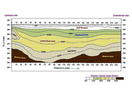
The seismic refraction method is based on the measurement of the travel time of seismic waves refracted at the subsurface layer's interfaces due to dielectric contrast. Seismic energy is generated on surface by a source ('shot' using Hammer & Plate, weight drop or small explosive charge).
Read More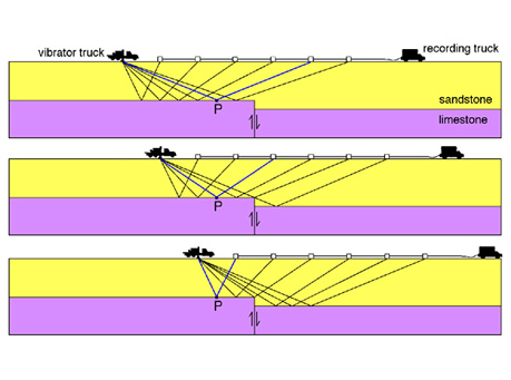
Deep seismic reflection surveying is the most advanced technique in geophysics today due to its major application for oil and gas exploration. This technique has other applications on a smaller scale, such as for civil engineering & infrastructure projects.
Read More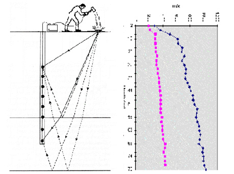
surface in increments down the borehole. Downhole seismic surveys are the simplest and cheapest method for borehole seismic techniques, as only one borehole is required for these surveys. Seismic energy is generated on surface at a fixed distance from the top of the borehole.
Read More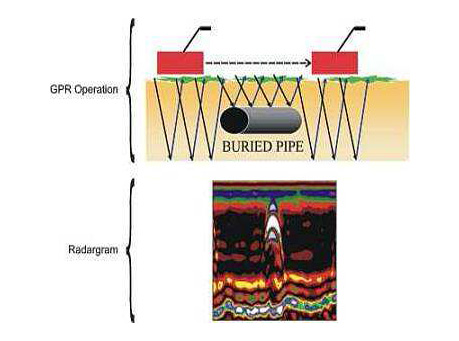
Ground penetrating radar is a cost-effective & nondestructive geophysical method, which is used for generating a continuous cross-sectional profile of the subsurface features, without drilling, probing, or digging.
Read More
This method consists of measuring the electrical resistivity of the ground through the use of a specialised borehole probe. This method allows us to sample the ground surrounding the borehole up to 300 metres in depth. In addition, a cross hole technique can be employed to obtain a 2-D resistivity section between two boreholes.
Read More
This method consists of the use of a specialized set of borehole antennae in adjacent boreholes, one transmitter and one receiver. This technique can be employed to obtain a 2-D section showing the changes in the electromagnetic propagation speed between two boreholes using the same software as for seismic tomography.
Read More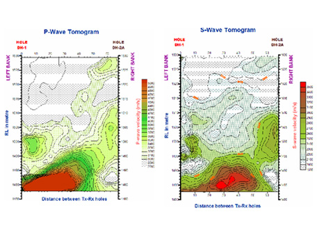
Seismic tomography is one of the latest high resolution geophysical cross-hole techniques for locating vertical subsurface anomalies between two or more drill holes using a pictorial display. Seismic tomography, as with medical tomography, allows us to image the interior of a given structure.
Read More
Hydrographic Survey is a survey of a body of water to determine several classes of data pertaining to it, such as depth, configuration, and nature of the bottom; direction and force of the currents; heights and times of tides; and location of fixed objects for navigation purposes.
Read More
Side-scan Sonar Survey is a type of Marine Survey which is used to efficiently and precisely map the larger areas of sea bed without any intrusion into the sea bed. Submerged ships, sea bed profile and other buried objects can be identified and mapped using this technique.
Read More
Sub-bottom profiling surveys are generally used to identify and characterize layers of sediments under the sea bed. Hard objects buried under the sea bed such as ships etc. can also be mapped using SBP surveys.
Read More
In the Electromagnetic (EM) surveys an artificial electromagnetic field is generated and penetrated into the ground using the transmitter coils and the response of the ground to this EM Induction is recorded using the receiver coil spaced at a fixed configuration.
Read More
Gravity Survey is a Geohysical Technique which is based on mapping the localised variations in the Gravitational Field of Earth caused by sub-surface materials. The anomalies mapped by Gravity Survey are caused by the density contrast in the subsurface material.
Read More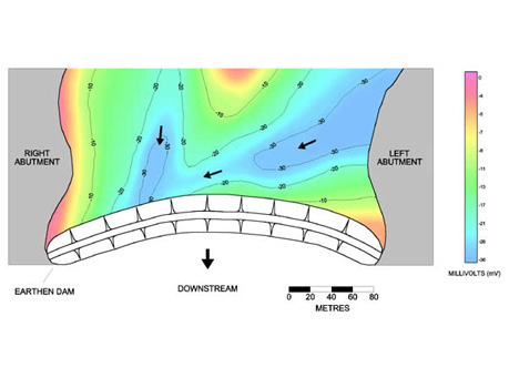
Spontaneous Potential or Self-potential surveys are conducted mainly for detecting the seepage or leakage from engineering structures like dams, dikes, landslide zones, canals wiers etc. SP Surveys have also been effectively used for mineral exploration and fault mappings.
Read More
Topographic Map is an indispensable tool for Government, Semi-Government, Public Sector, Corporate, Limited organizations, consultants and contractors. Topographic Survey is of utmost importance for Civil Engineers and plays vital role in all urban development projects, railway, highway, dam, bridge, building, irrigation, canal, tunnel, hydel and thermal projects.
Read More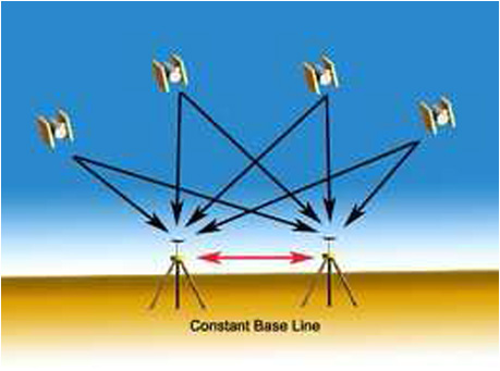
GPS technology has matured into a resource that goes far beyond its original design goals. These days scientists, sportsmen, farmers, soldiers, pilots, surveyors, hikers, delivery drivers, sailors, dispatchers, lumberjacks, and firefighters are using GPS in ways that make their work more productive, safer, and sometimes even easier. GPS plays an important role in establishing horizontal and vertical control for every type of topographic survey and GIS mapping.
Read More